ANCIENT ELEVATION SURVEYING IN NEW ZEALAND
HOW HIGH IS THAT MOUNTAIN?
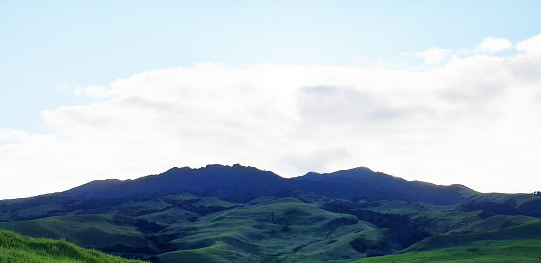
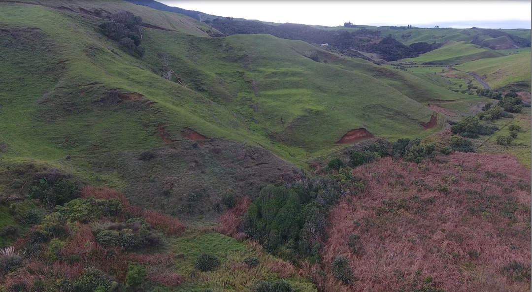
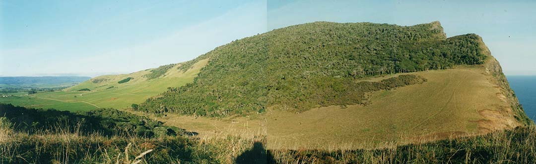
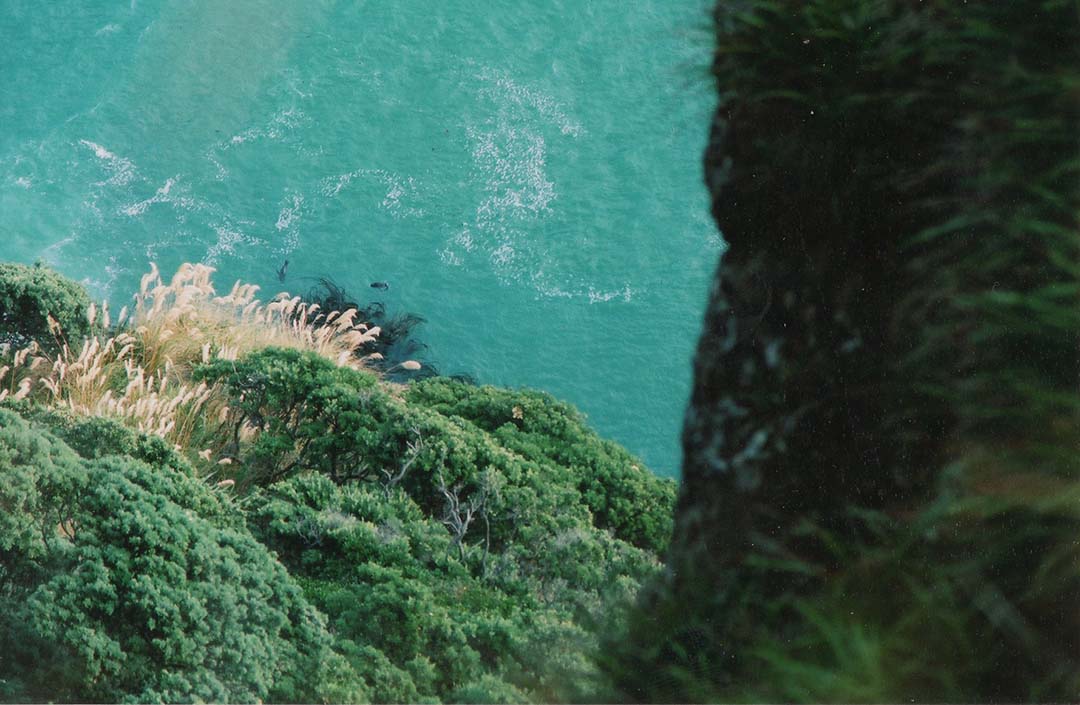
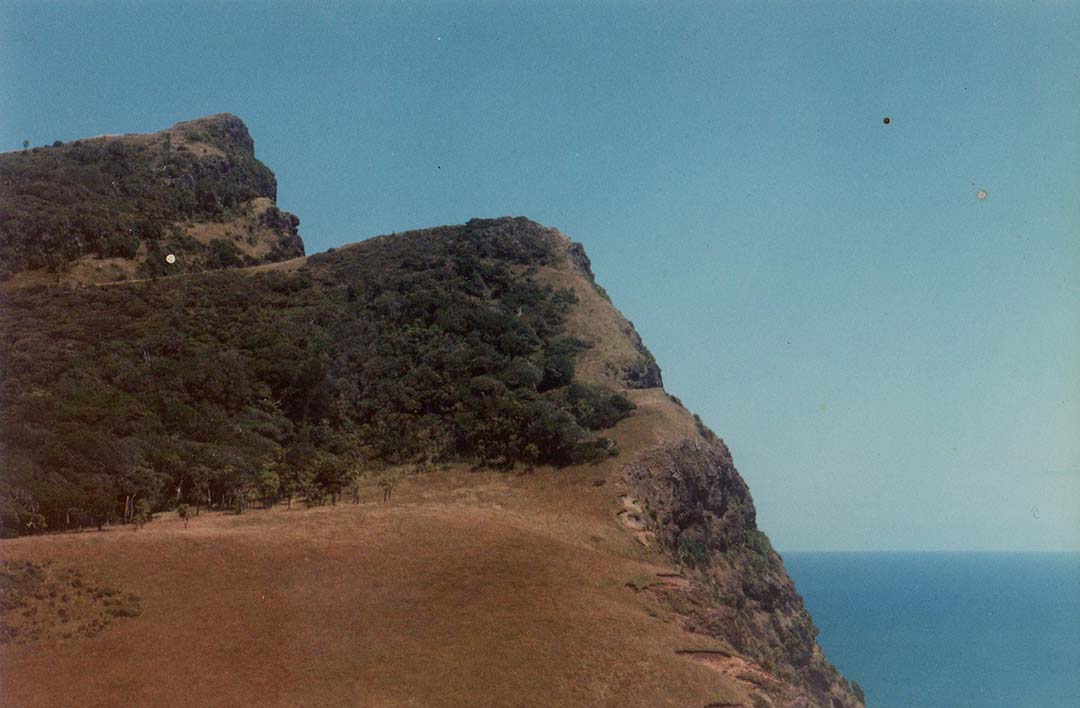
Mount Kariori is a majestic mountain that dominates the skyline at Raglan, New Zealand. This photo shows its western side, facing the sea and was taken on the morning of the winter solstice from an ancient, purpose built, solar observatory mound. The winter solstice sunrise ascended into the sky from the highest peak, giving a very accurate fix on the winter solstice day.
The coastal region, extending from north of Raglan harbour and down the coast southwards to Ruapuke and beyond was once host to a huge population, spanning thousands of years, and virtually uncountable numbers of earth embankment structures, many of great size, remain to this day. Added to that are many solar observatories and it seems that almost every location, where a sizable community dwelt, erected an observatory to fix onto a solstice or equinox rise or set. This activity of marking the main seasonal points of the year was to keep calendar counts running 100% true, as all planting, harvesting or other activities in their abundant society was regulated by the calendar.
These many structures were built in antiquity by a now exterminated civilisation known as the Patu-paiarehe or Turehu, locally referred to in the Raglan district as the Tuahu, who were very adept surveyors and astronomer-mathematicians.
Let's look closely at one of their sophisticated surveying structures, the primary purpose of which was for accurately determining the heights, above sea level, of lofty geological features like Mount Karioi, Mount Pirongia or even, speculatively, Mount Taranaki rising from the sea horizon over 100-miles distant but viewable in clear weather.
Local, long-term resident, Terry Stoddart has a keen eye when viewing the landscape around Raglan and can readily identify unnatural features that could only have been purpose-erected or landscape-modified by human intervention. Some of these features are subtle and could easily go unnoticed by the average observer, but do not escape Terry's very focused scrutiny.
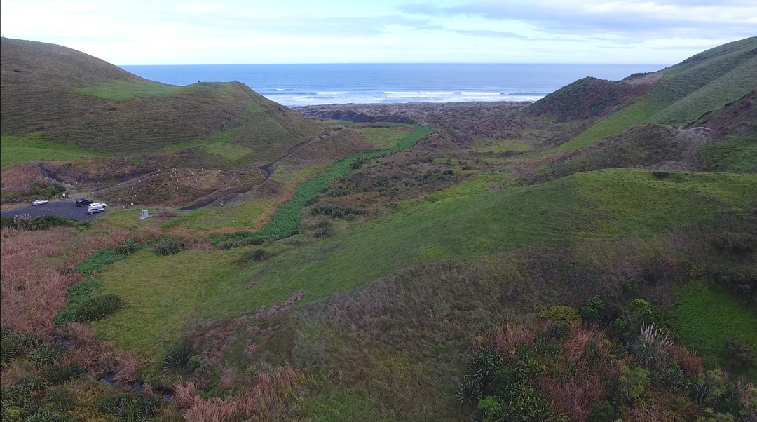
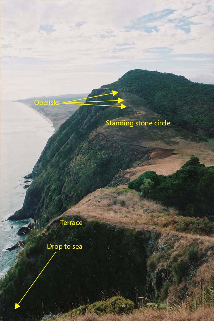
On the 20th of June, 2020, in conversation with Terry, he told me about an anomalous, double set of mounds at the southern stretches of Ruapuke beach at the outflow of the Ruapuke stream. The area is a small valley facing out to sea and on each side of the valley, at the seaward edge, are cliff-side mounds that appear to have been fashioned specifically to sit level with each other on the north & south sides of the valley respectively.
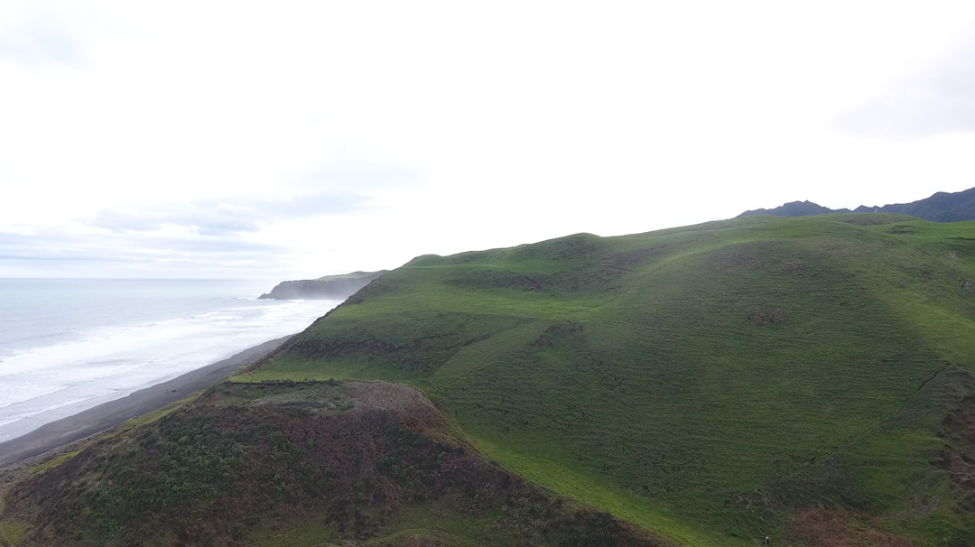
Left: the southern mound, with an adjacent assembly area and nearby amphitheatre. The mound itself is dotted with many sighting-pits and the dormant volcano, Mount Taranaki, can be seen 103.5-miles away SW at 201.5-degrees. Right: The northern mound, also with two assembly areas on tiers adjacent or above the mound.
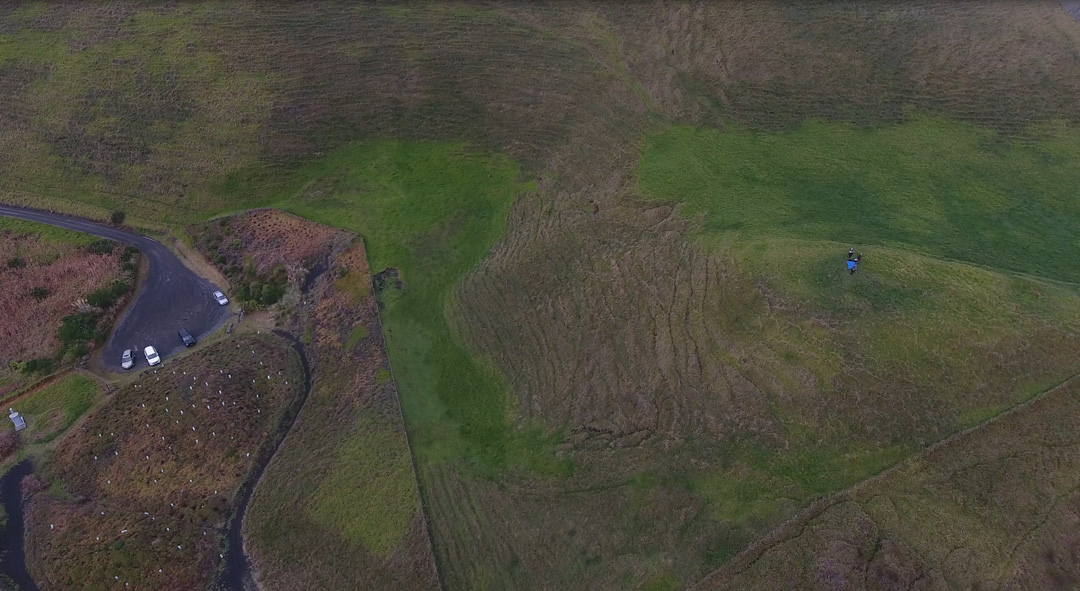
Our research group stands atop the southern mound, with the large, natural but purpose-modified amphitheatre to the right. Its floor has been built up into a slightly raised hump where orators or performance groups could entertain a sizable, seated crowd. The amphitheatre. provides shelter from the prevailing wind coming from the sea. To the southern side of the mound is a large assembly area and track-ways to higher ground above the sea cliff. Access to the beach is at the base of the mound.
The northern mound, with an adjacent assembly area and higher wide plateau that could also have been used for entertainment or observations to distant Mount Taranaki SW. It undoubtedly doubled as another amphitheatre, as we are finding many of them around New Zealand in locations where there were sizeable ancient populations. Of these locations, where large numbers of the Turehu people gathered in socially or for entertainment, one early New Zealand author wrote in 1855:
They are seldom seen alone, but generally in large numbers; they are loud speakers and delight in playing the putorino (flute); they are said to nurse their children in their arms, the same as Europeans and not carry them in the Maori style, on the back or hip. Their faces are papatea, not tattooed, and in this respect also, they resemble Europeans. They hold long councils, and sing very loud; they often go and sit in cultivation’s, which are completely filled with them, so as to be frequently mistaken for a war party; but they never hurt the ground… See: Te Ika A Maui, NZ and its Inhabitants, by Rev Richard Taylor, 1855.
I had a strong hunch as to why the ancient Turehu people would have laboriously hewn out or heaped up such large quantities of soil to build the two mounds, but whether or not the hunch was correct would depend on two factors:
1. Were the mounds actually level with each other?
2. Away from the sea shore, up behind us eastwards in the valley, there would need to be a set of obelisk markers or terraces, at ever-increasing heights. One such position would need to be level with the tops of the mounds and a yet more elevated position would need to show the sea horizon conjuncting with the tops of the mounds.
If this criteria could be satisfied, then it would essentially duplicate what I'd found many years ago at Maunganui Bluff, Northland, New Zealand and serve as a surveying site where the elevations above sea level of inland high country could be calculated with very reasonable precision.
In scanning the terrain eastwards, I was delighted to see a series of terraces climbing-up one of the declining ridges, a quarter of a mile from our position atop the southern mound. I had found what I was looking for and it became ever more apparent that this site was set up specifically for determining overland heights of inland mountains, hills or ridges, etc., and their elevations above sea level.
From our vantage point atop the southern mound the terraces were easily found (centre of the picture).
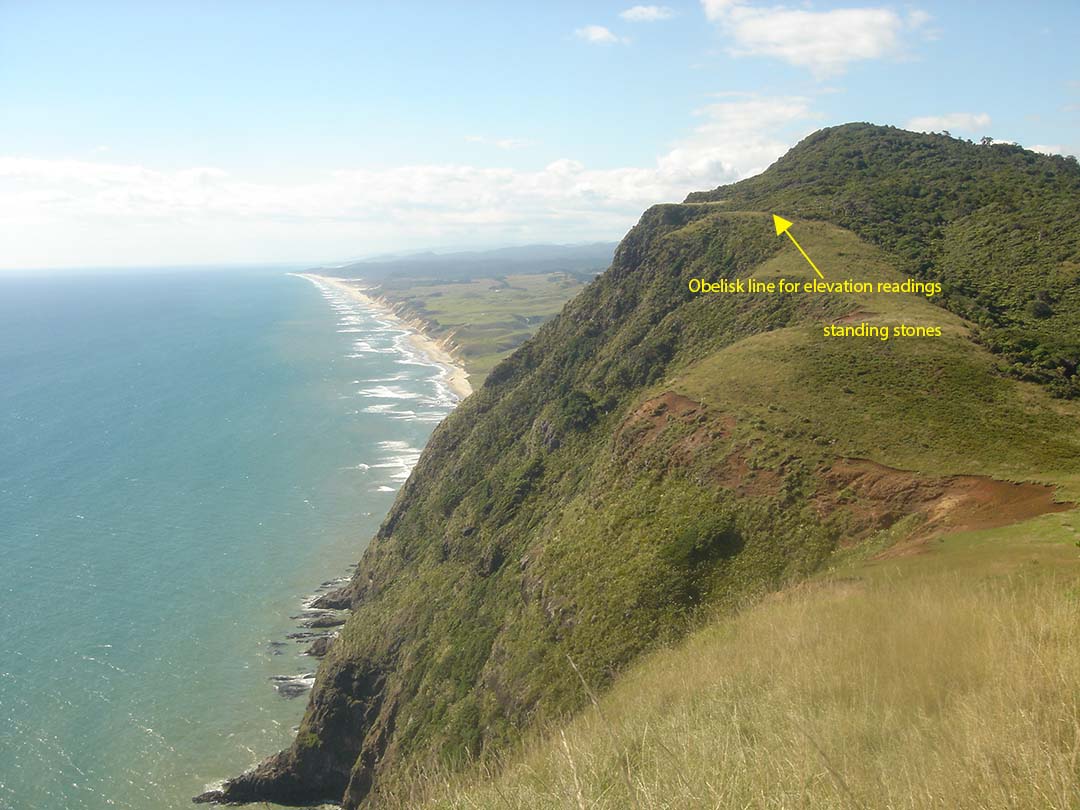
And a closer view.
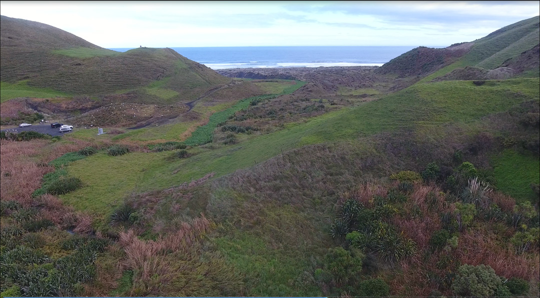
From a terrace position, the sea horizon perfectly touches the tops of both mounds, showing that they were purpose-erected to sit at the selfsame height above the beach and high tide mark. The mounds were, convincingly, fashioned to be seaside benchmarks for overland surveying.
The multi-tiered terraces as seen from the roadside and looking over the Ruapuke stream where raupo water plant thrives. From the terrace positions, upwards diagonal surveying lines would be transferred, by line if sight, at fixed, known angles to benchmark trigs on higher ground and the heights of hills and mountains around the horizon could be calculated from these second and third station positions.
Just forward of the terraces is a sighting pit that works as a part of the overall terrace system. The marked distance between the mound summits would have been a surveyor's baseline of known length, from which angle sight lines onto the terraces or other targets could be taken from each mound summit. From the angle information acquired from each mound, distances to overland targets could be calculated by trigonometry, which mathematical-geometric science has been around since the ancient Babylonians-Sumerians of 2000-3000 BC. See: https://www.sciencedirect.com/science/article/pii/S0315086017300691
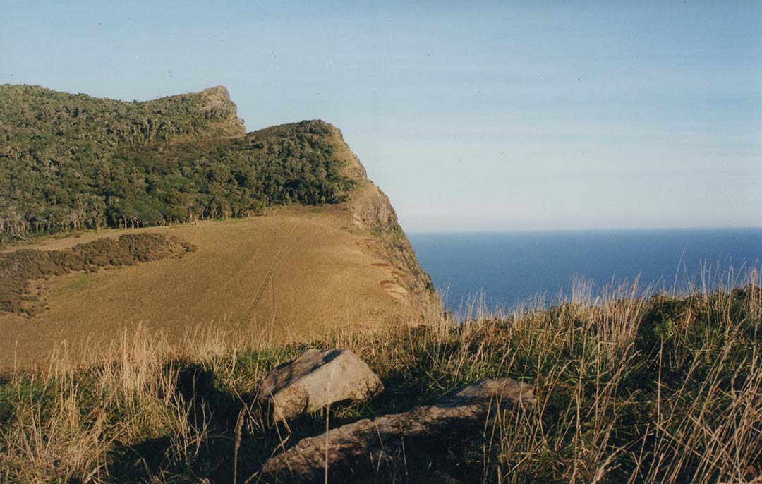
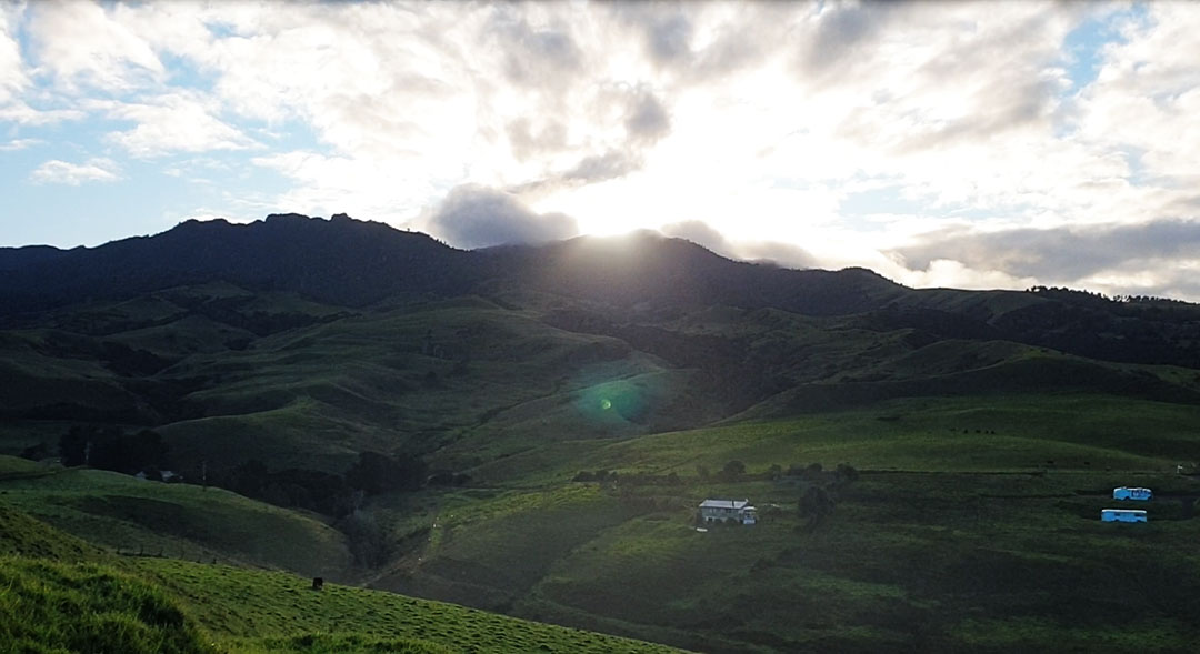
Driving up and out of the seaside valley into the high hill country and looking back. The seaside benchmark mounds are clearly visible in this photo, taken with a telescopic lens. In this higher elevation country there would have been a need to place markers (obelisks, sighting pits, etc.), of known, marked height above sea level, from which further, upwards angled shots could be taken to determine yet greater elevations of the highest points on the surrounding horizon.
CALCULATING THE DISTANCE FROM THE HIGH TIDE MARK TO THE TOP OF THE BENCHMARK MOUNDS
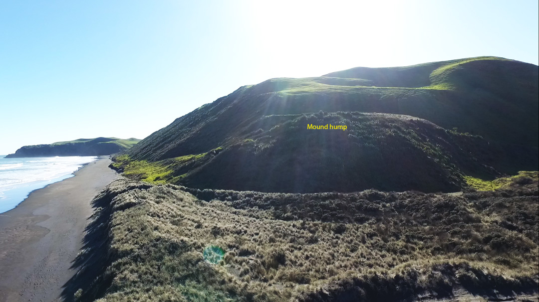
The northern mound, bathed in the morning sun of the winter solstice, showing its close proximity to the beach and sea. By stretching a rope down to the beach and high water mark, then doing the geometry to adjust for vertical height, it should have been a relatively easy task to calculate the summit's height above sea level.
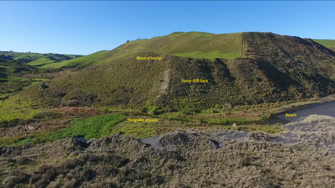
The southern mound cliff faces are more sheer and a greater distance from the sea than their northern counterpart. However the slow, meandering Ruapuke stream flows past the toe of the cliff at a level almost comparable to sea level. Again, working out the measured, vertical height of the mound's summit should have been relatively easy.
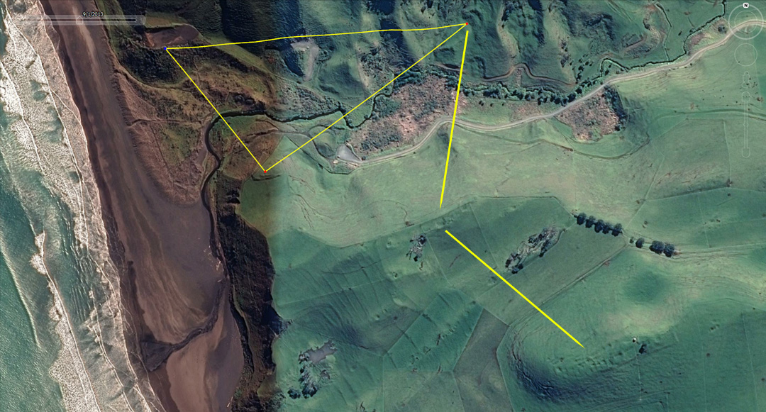
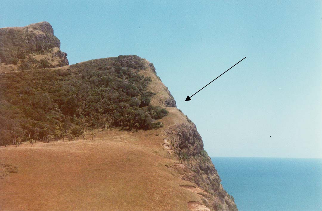
The triangle shown approximates the vectors between the mounds and their sight-line convergences onto the terraces. Arrow lines then run to clearly seen sighting pits on the ever more elevated ridges. The first sighting pit complex shown, away from the terraces, sits at 270-feet above sea level. From there a 2nd arrow commences and runs to secondary sighting pits situated on a ridge 480 feet above sea level, and so forth. Everything is being stepped-up to higher elevations, until the full panorama around the skyline comes into view.
The sight line from the southern mound to the terraces seems to have also functioned as a surveyor's baseline for calculating the distance to the first ridge line grouping of sighting pits shown in the above picture.
Of course, our establishment-aligned, politically-correct, New Zealand archaeologists would call these ridge line pits "kumara pits" for the storage of sweet potato and are blissfully unaware of the fact that many or most of these high country pits have a surveying and overland observation function.
All through the Ruapuke region there is little to suggest that the ancient Turehu people were preoccupied with warfare and few of the earth embankment structures have any real or recognisable defensive capability, necessitating food storage on high, palisaded ridges where one must stand and fight to ward off an enemy. There is little or no known evidence of defensive trenches, palisaded barriers or impregnable citadels from which an effective defense could be mounted.
Added to the above, our PC archaeologists are not allowed to admit that there were any human impacts upon the New Zealand landscape prior to about 700-years ago and that all the structures, found in their hundreds of thousand across the New Zealand landscape, are of recent origin, befitting the Polynesian-Maori epoch.
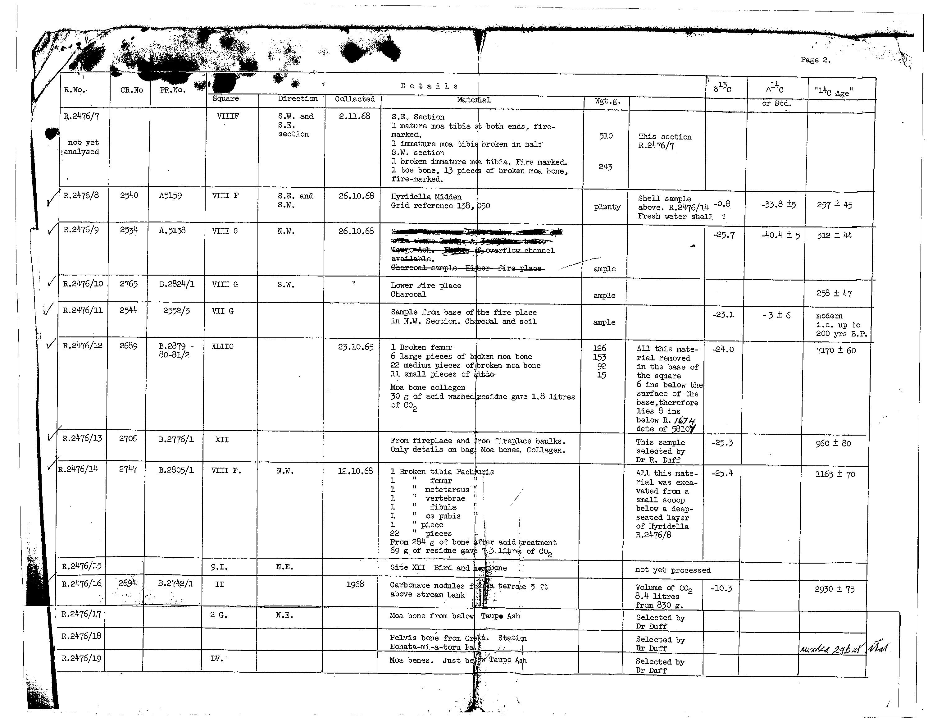
Strange that! ... as our DSIR (Department of Scientific and Industrial Research), Radiocarbon Dating Laboratory (1960s & 70s) provided proof that humans have occupied New Zealand for thousands of years. Their oldest published radio carbon date, related to a human presence, is 7170-years, plus or minus 60-years before 1950.
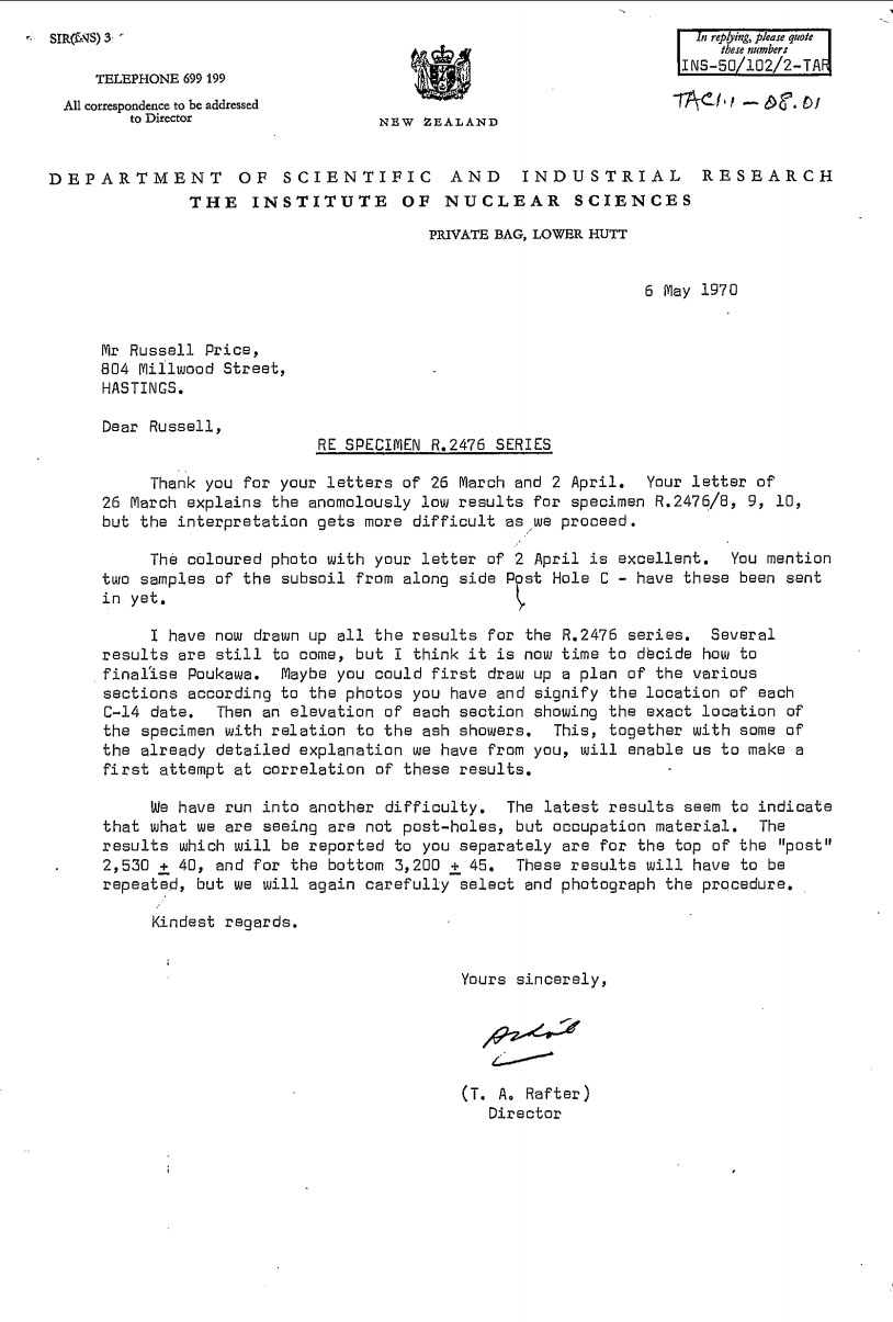
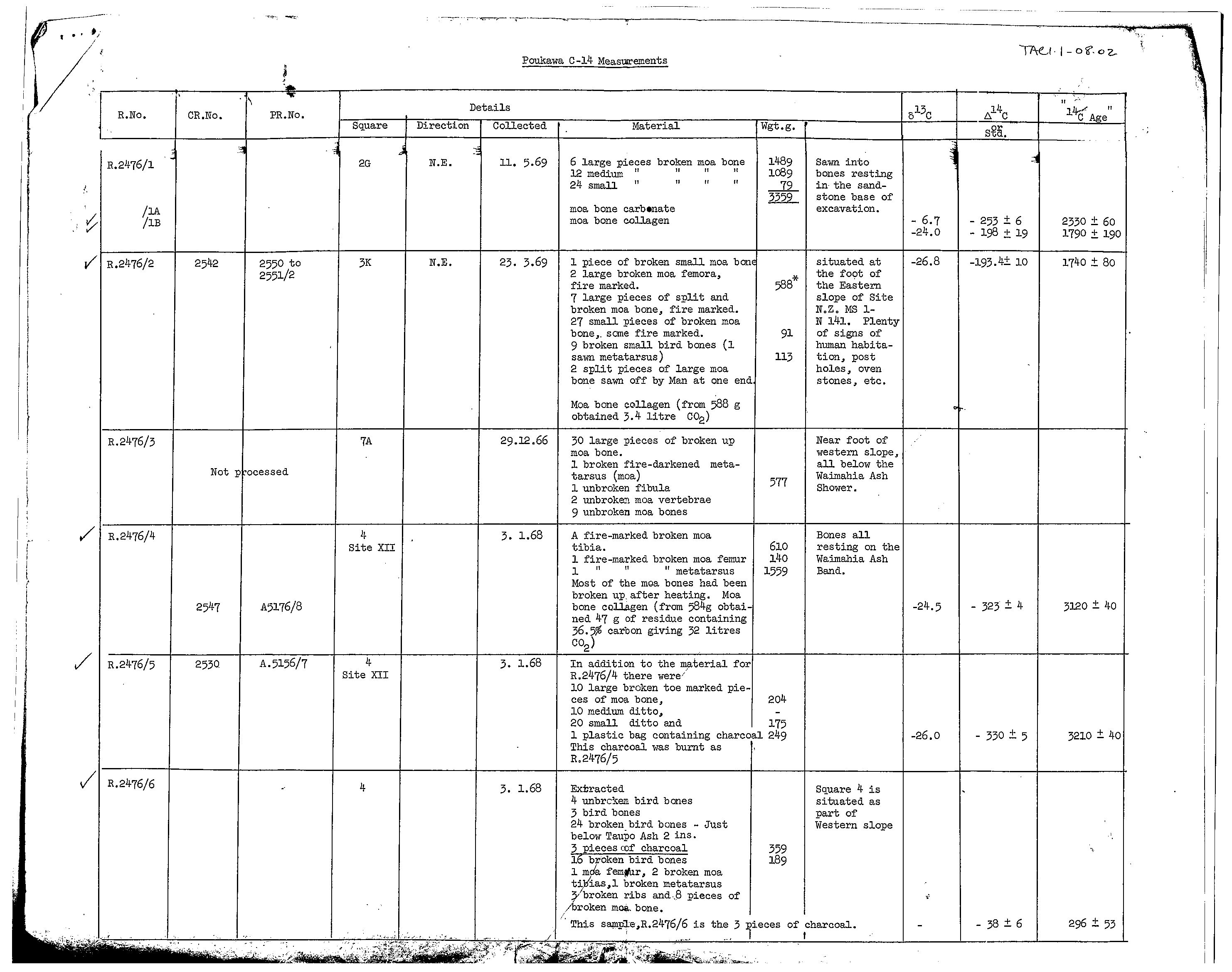
To see undisputable results of very ancient human occupation of Poukawa, New Zealand, go to the 3 links below and magnify the C14 sample figures for clear reading.
http://celticnz.co.nz/Kaiwhakaruaki/Letter1.jpg
http://celticnz.co.nz/Kaiwhakaruaki/Carbondating2.jpg
http://celticnz.co.nz/Kaiwhakaruaki/Carbondating3.jpg
Thankfully, there was, once upon a time, before the New Zealand history book-burning era of the 1970s, a far more honest appraisal of true, regional history, much of it based upon Maori oral traditions passed down through many generations by the learned elders.
SO, WHAT DID THE LEARNED MAORI ELDERS SAY ABOUT THE TUREHU PEOPLE?
'Nga Turehu and Patu-paiarehe
Nga Turehu are also depicted as a supernatural people and are usually associated with elves and fairies (the fair skinned Patu-paiarehe). However, for a considerable period they inhabited the everyday world and for approximately ten generations they coexisted in the South Island (of new Zealand) with the Polynesian descendants of Maui - i.e. the true Maori people from Hawaiki. Eventually, Nga Turehu, described as being fair people with red or blond hair, were displaced into the hinterland. In Te Tau Ihu (the Maori language name for the top section of New Zealand's South Island) they were believed to have occupied the hilltops and bush fastnesses in the Marlborough Sounds and Pelorus Valley until comparatively recent date when they were smoked out by bush fires. The Turehu and Patu-paiarehe were expert netmakers and clothweavers, and it is from these people that Maori acquired the same skills ... John White's (early New Zealand historian) informants in the 1870s and 1880s asserted that by the time of the demise of Nga Turehu, Maui's descendants had occupied New Zealand for 36 generations (i.e. 39 - 40 generations to the present day - a span of 1000 years).' See: Te Tau Ahu o Te Waka, by Hilary & John Mitchell, Vol. 1, pg. 44, Huia Publishing, 2007.
‘The Maori regales us with several tales that are supposed to illustrate a period when the Maori people were living here on sufferance, as it were, under the mana of the Turehu or Patu-paiarehe, the true lords of the soil. Many different names are used to denote this forest folk or fairies as our writers often term them, though the Maori concept is not that of a diminutive fey or elf like folk, but rather that of a people of ordinary stature and appearance, save they are said to have been fair-skinned and fair haired’ (see Maori Religion, by Elsdon Best).
‘Besides gods the natives believed in the existence of other beings, who lived in communities, built pas, and were occupied with similar pursuits to those of men. These were called Patu-paiarehe. Their chief residences were on the tops of lofty hills, and they are said to have been the spiritual occupants of the country prior to Maori, and to retire as they advance. The Wanganui natives state, that when they first came to reside on the banks of the river, almost all the chief heights were occupied by the Patu-paiarehe, who gradually abandoned the river, and that even until a few generations ago, they had their favorite haunts there. These may be accounts of an aboriginal race mixed with fable; there are several things to warrant the idea that the Maori were not the first inhabitants of the land.
They are seldom seen alone, but generally in large numbers; they are loud speakers and delight in playing the putorino (flute); they are said to nurse their children in their arms, the same as Europeans and not carry them in the Maori style, on the back or hip. Their faces are papatea, not tattooed, and in this respect also, they resemble Europeans. They hold long councils, and sing very loud; they often go and sit in cultivation’s, which are completely filled with them, so as to be frequently mistaken for a war party; but they never hurt the ground…
The belief in the Patu-paiarehe is very general; many have affirmed to me that they have repeatedly met with them. Albinos are said to be their offspring, and they are accused of frequently surprising women in the bush.’ (see Articles from “Te Ika A Maui, NZ and its Inhabitants”, by Rev Richard Taylor, written in 1855; facsimile reprint in 1974 A.H. & A.W. Reed).
The Turehu folk were very adept artisans and had localised workshops all over New Zealand, where much sought after resources were available for trade, including the hardest stone for adze production, flint for fire-making, obsidian for cutting tools, etc. The ancient people venerated greenstone (jade - nephrite) and were experts in carving this very hard, highly-treasured stone, found only in one remote, South Island region, but traded over the entire length and breadth of New Zealand.
Maori oral tradition states that the source of greenstone was the progeny of Tangaroa and the stone itself was often associated with fish. Tangaroa, in one of his assigned roles, represented all fish. The Dominion Museum article devoted to Nature Myths, says of greenstone:
“One quaint old folklore repository of Matatua district told me that Poutini the origin of greenstone is one and the same as Poutini the star. His people are the greenstone folk, a people who descended from the heavens and dwelt at Hawaiki, but in latter times came to New Zealand. These greenstone folk were persons of importance and had many chiefs. They were attacked here and lost a number of their people, who were slain, which was a benefit to the Maori people. These slain and captured greenstone folk represented blocks of greenstone acquired by the Maori and famous greenstone artefacts. Greenstone is often alluded to as the whatu o Poutini or “stone of Poutini”, also the ika a Ngahue, or “fish of Ngahue”. One old tale speaks of greenstone having been alive, and when caught it was cooked in the oven.”
This final statement alludes to the latter era of hostility, where the Turehu people (the greenstone folk) were hunted and cannibalised (cooked in the oven) by the Maori warriors.
Many hundreds of additional references, from our older, out-of-vogue history resources, related to the pre-Polynesian inhabitants of New Zealand, could be cited.
SO, WHERE ELSE IN NEW ZEALAND DID THE ANCIENT TUREHU APPLY THE SAME ELEVATION SURVEYING TECHNIQUE?
At Maunganui Bluff, Northland, New Zealand there is much purpose-placed, ancient stonework (obelisks, cairns) throughout the Waitapu Valley and on the slopes or crown of the high bluff itself. Likewise, there are many sighting pits for surveying and, in this photo, the foreground terrain has a dual hubstone, standing stone circle, many component boulders of which are of an impressive size.
From the central region of the standing stone circle the "V" in the skyline (left), where the lower end of Maunganui Bluff declines down to conjunct with the background (darker haze) Tutamoe Range, the degree angle around from true north is 90-degrees. The "V", sitting at true east, therefore provided the ancient surveyors on the standing stone site with a fix reference onto a primary point of the 360-degree compass.
The Maunganui Bluff overland complex of purpose-placed obelisk, mound, sighting-pit or cut benchmark features was an ancient school of learning, where initiates clearly learned surveying, navigation and astronomy.
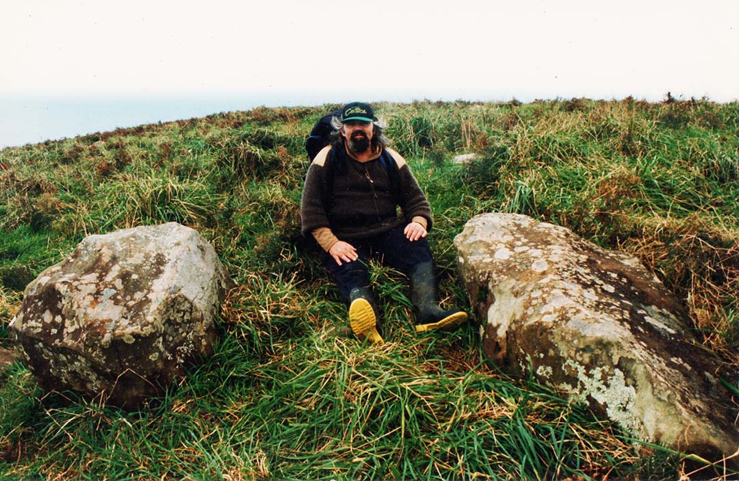
The author, over 20-years ago, sitting between component markers of the Waitapu standing stone circle. To the left is the southern, tumbled-sideways, hubstone and to the right is one of the giant, recumbent, shark's fin shaped stones that once stood upright. Behind, towards the sea horizon, are many more component boulders hidden by the high grass. The panoramic views from this standing stone site are magnificent.
From the Waitapu standing stone observatory, this is the view to the cliff face of Maunganui Bluff. Note that above the sea horizon line there's a distinct notch, situated 2200-feet away in the cliff face. As one moves more seawards of up closer it becomes visually evident that a huge hunk of cliff face has been laboriously hewn-out to create the notch and a level ridge. In the foreground of this picture are yet more tumbled component boulders of the Waitapu standing stone circle.
As can be seen from this picture, there is a horizontal, hand hewn terrace high on the cliff face and behind the terrace it's an almost sheer drop down to the water's edge lapping the base of the cliff.
Lying on one's belly and peering over the back of the level terrace is not for the faint hearted or anyone scared of heights and precipices. In this picture seals can be seen frolicking in the ocean at the base of the sea cliff. The ancient surveyors would have dropped a rope down on a slight diagonal to the high tide mark, made an angle adjustment to calculate vertical height from sea level, then transferred that reading to secondary stations.
The rear side of the hand hewn terrace is seen here. Across the valley on a flat plateau is the very impressive standing stone circle, with the many component boulders tipped over and lying recumbent in the long grass. Above the former standing stone observatory the gradient rises diagonally to a high plateau and on this slope there is a line of carefully placed obelisk markers that relate specifically, in a surveying sense, to the level terrace on the cliff face seen in the foreground of this picture.
The obelisk line works in the following manner: One sets up a theodolite by an obelisk low on the slope above the observatory plateau and ascertains that they are on a perfect level with the benchmark cleft, level terrace across the valley. One then moves to obelisks at higher levels in the line and sees the sea horizon begin to rise accordingly. At the final, most elevated obelisk position the sea horizon perfectly meets the hewn terrace on the cliff across the valley.
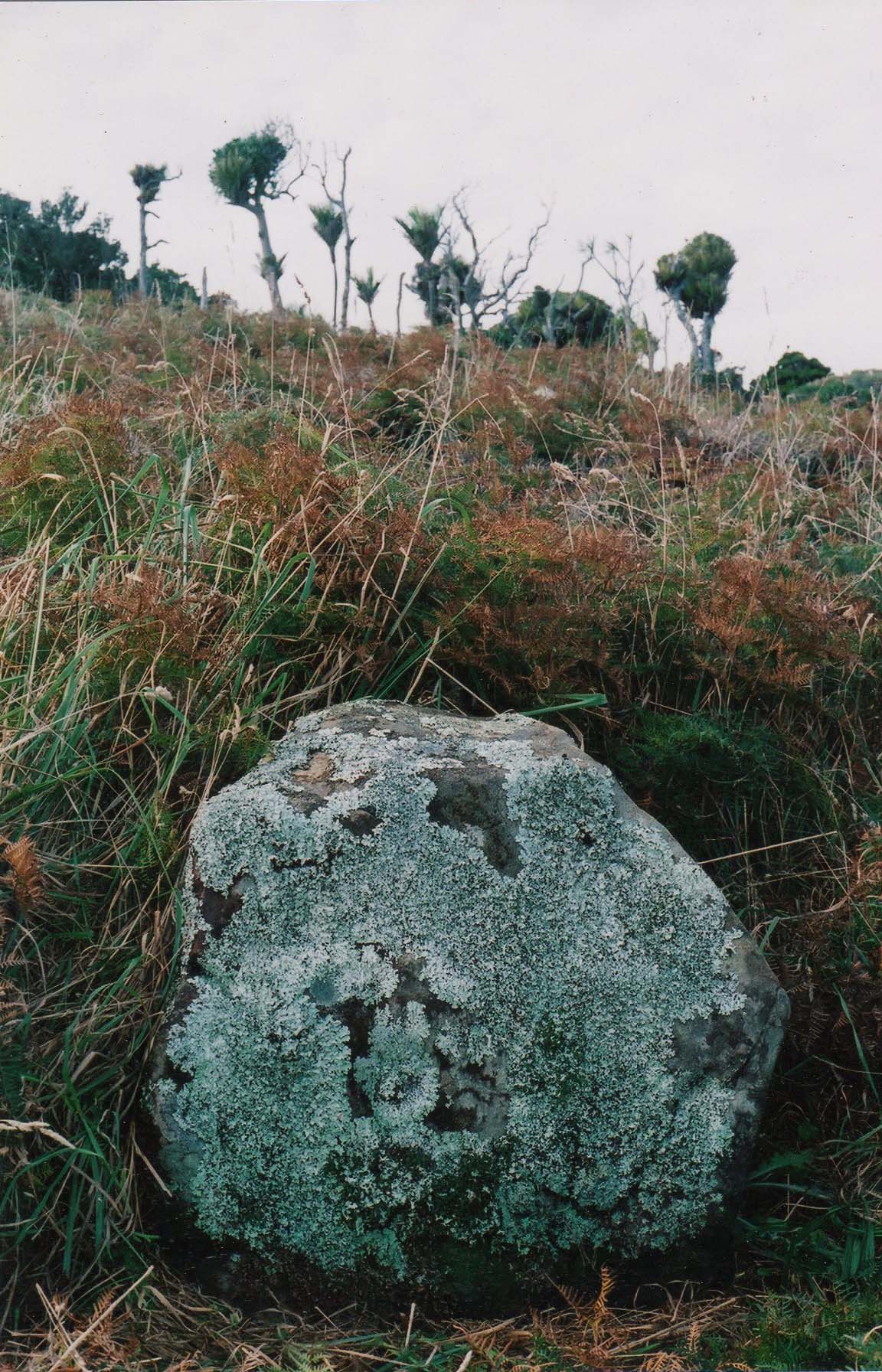
One of the anciently purpose-placed obelisks for working out elevations, above sea level, of hill or mountain targets standing away from Maunganui Bluff and the Waitapu Valley of Northland New Zealand.
In this picture the benchmark terrace is level with the obelisk across the valley, as verified by use of a surveyor's theodolite.
In this picture the obelisk position sits at a level wherein the sea horizon conjuncts with the benchmark cleft cut into the sea cliff.
It can be readily seen that the elevation surveying methodology between Maunganui Bluff and Ruapuke are essentially the same. For additional information concerning what's happening at Maunganui Bluff see: http://www.celticnz.co.nz/SurveyorsNZ/Ancient%20New%20Zealand%20Surveyors.htm
SO, WHAT CALCULATION TOOLS WOULD ANCIENT NEW ZEALANDERS HAVE NEEDED FOR THIS WORK?
Suffice it to say that the ancient Turehu were very adept astronomers and their many solar observatories attest to the fact that they were preoccupied with following the rise and set positions of the sun throughout the year, especially the summer & winter solstices or autumnal and vernal equinoxes. The same would hold true of fixes onto the positions of the moon and stars throughout the year.
Although surveying or navigational instrumentation has rapidly advanced technologically in the past few centuries, especially in the more recent electronic age, the fundamental practices employed have remained the same and been around for millennia. Simple, static surveying instruments of several thousand years ago were capable of producing results of very reasonable accuracy in positional navigation or overland surveying, including elevation work.
Within the great civilisations of antiquity knowledge was gained and added to in steps from generation to generation. Over long periods, formerly difficult questions could be answered such as, how far away is the sea horizon when standing on a beach with the tide lapping at one's feet? ... or ... if one moves in measured increments to higher levels above the beach, how far is it to the sea horizon at greater elevations?
Over time, increasingly accurate formulas were devised to make such determinations, resulting in the invention of such items as calibrated cross-staffs, the fore-runners to sextants. These staffs, increasing in sophistication as the centuries wearied on, are known to have been used by the ancient Chaldeans and many other groups of antiquity, filtering down to the Greeks and Romans.
There were also plumb-bobs, water levels, and the use of the 360-degree calibrated discs for diagonal, upwards-angle calculations to stars or mountain tops, or flat-plane angle fixes overland to landmark positions. A surveyor's plane-table, dated to about 2000 BC, was exhumed from a grave at Bush Barrow, near Stonehenge and rudimentary variations on the more modern dumpy level, calibrated for either flat-plane or vertical-diagonal angle calculations, were used by the ancient Egyptians.
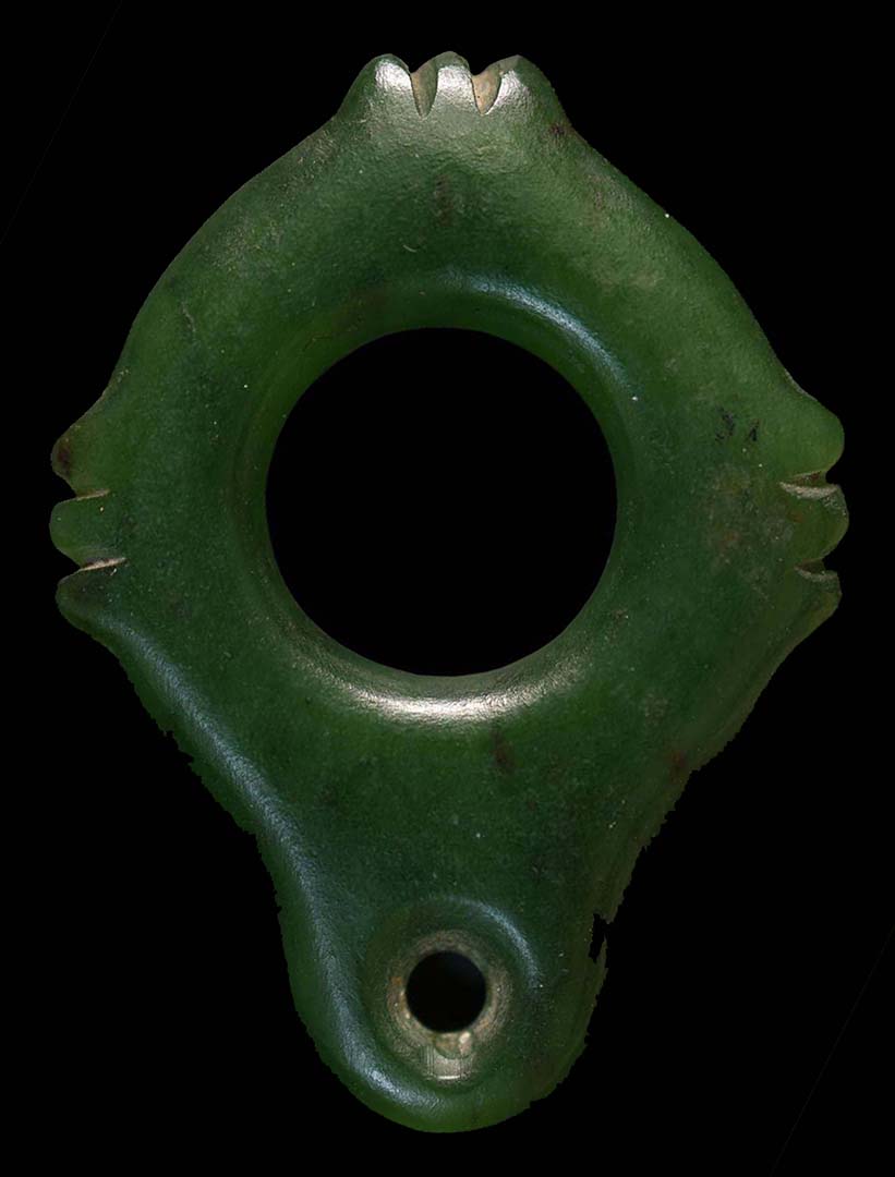
This New Zealand greenstone treasure would have been very difficult to carve and was obviously never intended for use in a lowly or frivolous function. It's shape is cross-like (cruciform) and, with such an instrument up to the eye and peering through the centre hole to true north, the right notched arm would represent true east and the left true west, with the overland view directly behind the observer being true south. The object appears to be a navigational aid for a wayfarer or surveyor and the bottom hole would, undoubtedly, have been used to insert a chord for suspending the item as a pendant around the neck. Its given dimensions are 55 X 60 mm (2.16 X 2.4 inches).
A larger, more elongated, vertical cross arm version of this, fabricated from light weight wood, with the cross-arm sliding forwards and back along a calibrated staff, would have functioned effectively for positional navigation and elevation surveying.
When doing angle or eclipse fixes onto the sun, with its blinding light, ancient New Zealanders had ready access to obsidian (black, volcanic glass) that could dim the sun's glare like the lens of a welding helmet. The ancient Mayan's of Chichen Itza are reported to have used obsidian for their observations of the sun.
OPEN-AIR UNIVERSITIES ... THE GREAT SCHOOLS OF LEARNING IN ANCIENT NEW ZEALAND
During the 10 generations that Maori co-existed peacefully with the Turehu tribes they gleaned practical knowledge from the earlier inhabitants. Some of it endured beyond the era of hostility where the Turehu were attacked and hunted into virtual extinction by the Maori warriors. Certain traditions remained, in part at least, and Maori developed their own forms of the whare-wananga or schools of learning.
There is much to suggest that a great school of learning existed at Ruapuke (pit upon a hill or mound).
Historian Elsdon Best, who attained the status of a tohunga (high-priest) through his 25-years of living with and being trained in Maori lore, wrote the following:
The whare wananga or house of occult lore, was an ancient institution. The original one, known as Rangiatea, was situated in the uppermost of the twelve heavens. The first one on earth was erected by one Rua-te-pupuke (pit of the wise one upon the mound), who is the personification of knowledge.
The similarity of the place name Ruapuke to the name of the highly enlightened sage, Rua-te-pupuke would seem to suggest that, within the region of Ruapuke, a great school of learning existed.
This is further borne out in the name of a region on the Ruapuke coast formerly called Koreromaiwaho (the recounting of ancient wisdom on the open seaward coast). Certainly, the name Koreromaiwaho is still used to describe terrain very near to Manuaitu (Bird of ill omen or calamity) Pa or ridge to the immediate north of the area deemed Koreromaiwaho today and might well have encompassed the wider district in more ancient times.
The present name of the ridge might be due to the fact that this was the residence of the most murderous Maori chief of recorded New Zealand history, Te Rauparaha, who left this location with his warriors in about 1820 to wage war upon and murder-cannibalise tens of thousands of people in the northern part of the South Island (Te Tau Ahu o Te Waka) and elsewhere in the North Island. Prior to this he had already decimated or subdued his neighboring tribes around Kawhia in his home district.
What is particularly significant about this elongated earth mound called Manuaitu is that a small offshore island, called Gannet Island, is the spot where the equinoctial sun is seen to alight upon the island for an observer standing upon, what's now called, Manuaitu Pa. In other words, it's a functioning solar observatory. Added to that, the observer's position for witnessing the equinoctial sunset onto the offshore island is at or near the venerated Tuahu stones, the origins of which can be attributed to the ancient Turehu people.
A tall Tuahu stone and a shorter one were erected on a hillock hump adjacent to where one stands to witness the equinox at Manuaitu Pa and and a Tuahu position was once referred to as a "listening post" ... 'a place where the spirits and the gods could rest and be available for the benefit and welfare of the pa (village or fortified position) and its inhabitants'. Under what was conceivably the former name of this location, Koreromaiwaho, the Tuahu hillock could be classed as a place of learning. This seems to be further supported by the fact that there is no stream nearby and those gathered at or near the tall and short , Tuahu stone's listening post for ongoing instruction would need a support group to supply drinking or cooking water and other amenities. Also, instructors or students were never permitted to have or eat food in near proximity to the stones.
'Let this be quite clear: The tuāhu (or ordinary altar) is outside—not in the house. There are two (proper) sites for the tuāhu, one near the latrine, one by side of a tomb—those are the only proper sites. The reason of this is lest (the tuāhus) should be desecrated by the approach of food, or by food being suspended near them.' See: The Lore of the Whare-wananga, chpt. 1, written down by H.T. Whatahoro, from the teachings of Te Matorohangi and Nepia Pohuhu, priests of the whare-wananga of the East Coast, New Zealand. Translated by S. Percy Smith.
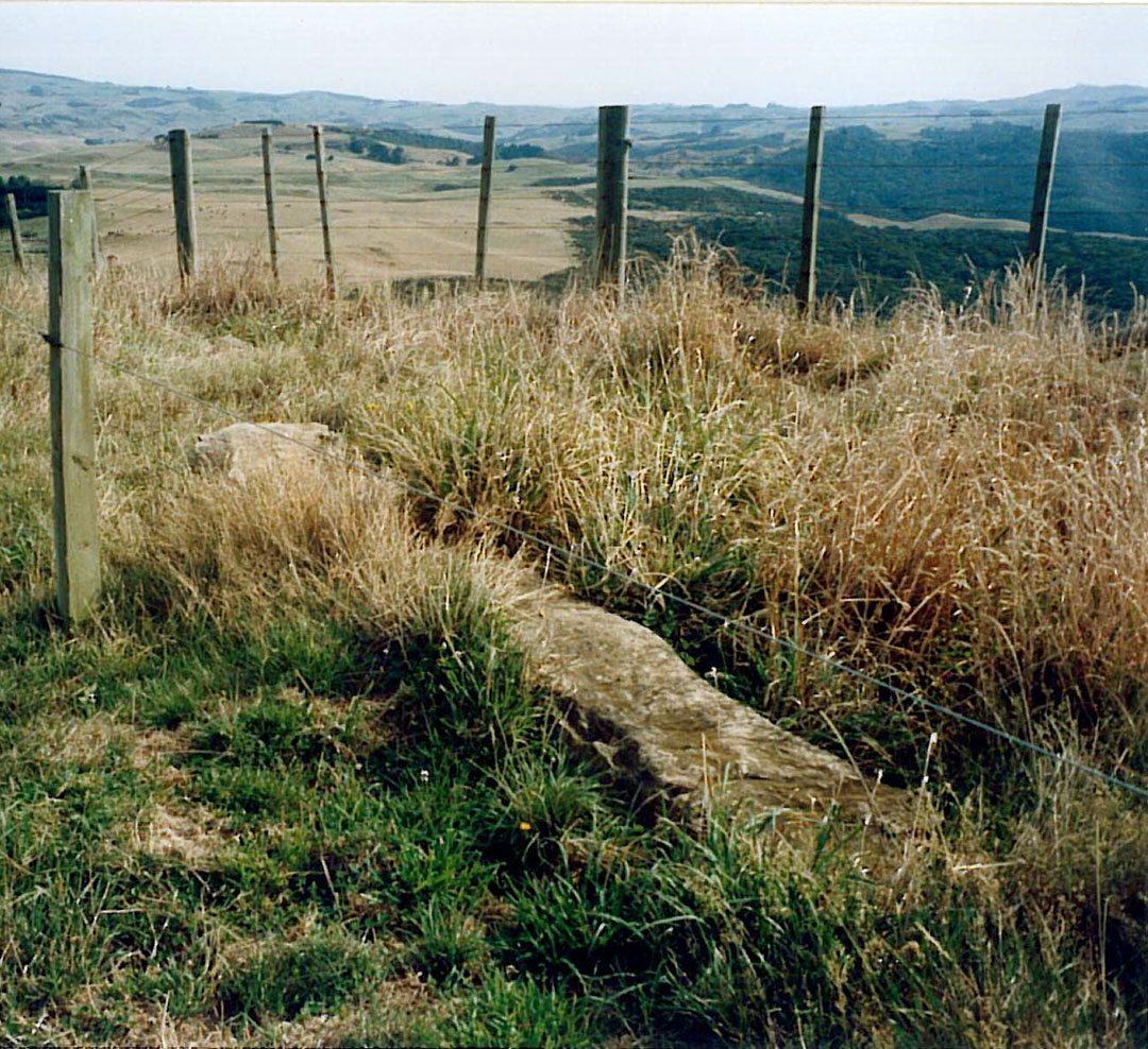
The tall tuahu stone lies recumbent on the summit of the mound at Manuaitu Pa. It measures 10.8-feet long (3.3-metres).
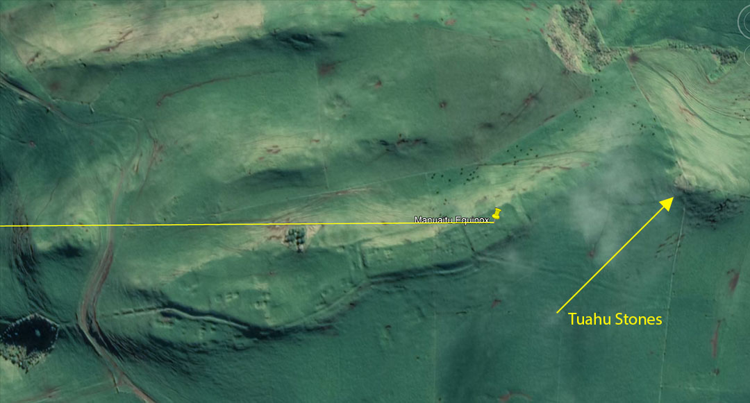
An equinox line begins at Manuaitu ridge line mound and extends westwards across the seacoast to resolve on Gannet Island, 12.6 miles out to sea. From the observer's position on the ridge line mound, the equinoctial sunset would be seen to alight onto Gannet Island. The equinoctial sunrise, by consequence, would be on a significant hump in the centre section of Mount Pirongia to the east. Also, from this observatory position, Mount Taranaki can be seen 100-miles distant on clear days at an angle of 202.9-degrees, yet another surveying related plus for this site.
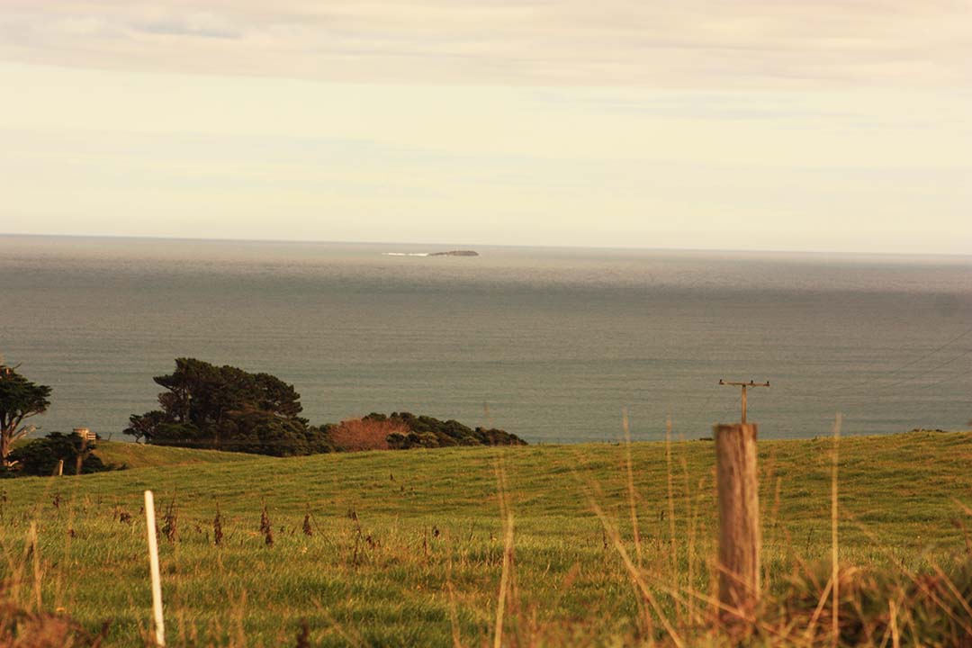
A photo telescope lens picture of tiny, windswept, Gannet Island where, from Manuaitu Pa, the equinox sunset alights.
Tohunga-historian Elsdon Best further writes:
'In pre-European times the Maori had evolved a peculiar institution in the form of a school of learning. In order to preserve tribal lore it was necessary that it should be taught to a certain number of young men of each generation, hence the institution known as the whare wananga or whare kura. Each tribe of importance contained certain men skilled in tribal history, in long conserved myth and ritual. To these men were given the task of transmitting the prized lore to young men selected as pupils ... The teaching of all these tapu (sacred or secret) matters was necessarily itself and extremely tapu business and no person not engaged in either teaching or learning was allowed to be present. In some cases instruction was given at some secluded spot away from the village; in others the lessons were conducted in a house that was put under tapu and to which the public had no access at the time.' ... In his settlement of Polynesia the Maori was compelled to dwell in isolated, far-sundered communities and then each one had to preserve its own lore as best it could. Some communities seem to have succeeded much better than others. In New Zealand the institution was kept up faithfully by the principal tribes and we have the names of many of the old houses. The Takitumu folk of the eastern side of the North Island were perhaps the most advanced in regard to this mode of preserving knowledge. Some of the whare wananga were famous for many generations, such as "Ra-wheoro" at Uawa. In such cases the actual house was rebuilt when it fell into disrepair, for it was not a Maori custom to repair a house. In other cases the whare wananga was but a name and a system; no special house bore the name and the knowledge pertaining to it might be taught in the open air or in any house set apart for the purpose.' See: The Maori As He Was, by Elsdon Best, pp. 84 - 85, Government Printer, Wellington, 1932.
For a more comprehensive account concerning the lore and practices of the whare wananga institution, see: The Lore of the Whare-wananga, written down by H.T. Whatahoro, from the teachings of Te Matorohangi and Nepia Pohuhu, priests of the whare-wananga of the East Coast, New Zealand. Translated by S. Percy Smith.
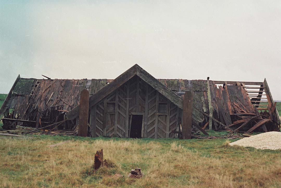
The crosshouse of Miringa te Kakara, the last know surviving whare wananga building of the Takitumu people of the Central North Island, seen here in disarray before being burnt down in 1983. It's exact positioning on the landscape and measurable geometric features show that many surveying and astronomical features were built into its dimensions and angles, such as the 3,4,5 triangle. Photo courtesy of Jan & Ron Raison. For further information see: http://www.celticnz.co.nz/Crosshouse/Crosshouse1.html
The New Zealand whare wananga institution is virtually identical to the druidic institution of pre-Roman Britain. As Julius Caesar said, concerning the Druids of Britain in his day:
'They do not think it proper to commit these utterances to writing, although in all other matters and in their public and private accounts they make use of Greek characters. I believe that they have adopted the practice for two reasons- that they do not wish the rule to become common property, nor those who learn the rule to rely on writing and so neglect the cultivation of memory; and, in fact, it does usually happen that the assistance of writing tends to relax the diligence of the student and the action of memory...They also lecture on the stars in their motion, the magnitude of the Earth and its divisions, on natural history, on the power and government of God; and instruct the youth in these subjects' (see De Ballo Gallico, VII, 15, 16.).
The late era Druidic schools that Julius Caesar commented about, undoubtedly, had a pedigree back to similar schools maintained during the Neolithic and Bronze Ages. British historian, Isabel Hill Elder, commenting on the Druidic schools, writes:
'The students at these colleges numbered at times sixty thousand of the youth and young nobility of Britain and Gaul. Caesar comments on the fact that the Gauls sent their youth to Britain to be educated...It required twenty years to master the complete circle of Druidic knowledge. Natural philosophy, astronomy, mathematics, geometry, medicine, jurisprudence, poetry and oratory were all proposed and taught-natural philosophy and astronomy with severe exactitude' (Elder refers to Strabo I IV, page 197. Caesars Comm. Lib V. Sueotonius, V Calegula. E. Campion, Accounts of Ireland, pg. 18.).
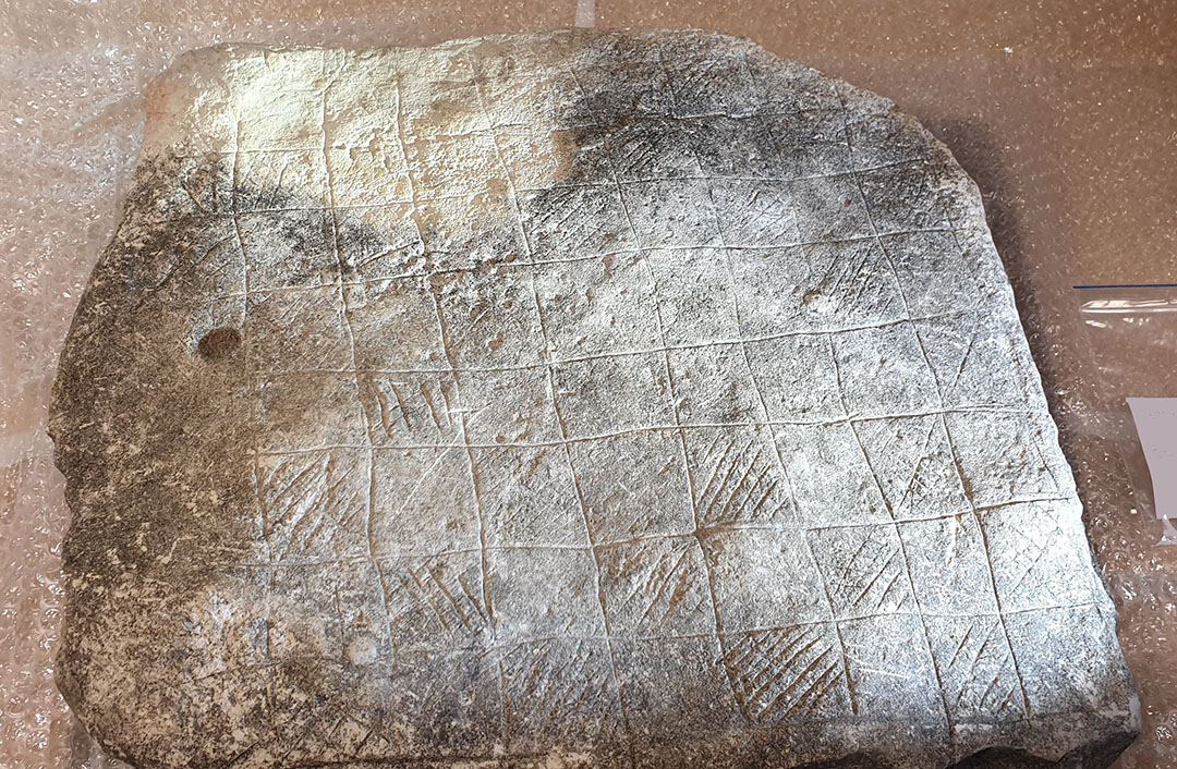
One of two large, flat slab incised stones found in the Raglan area, which intimate some kind of calculation or counting function within the individual squares. Some longer stroke, diagonal crossing lines traverse several squares in a single stroke. This slab is obviously very old and was discovered partially exposed in an eroding bank at the sea-front.
What the function of this matrix was is yet to be discovered. The second of these large, flat and incised slabs was found at a solar observatory site and is composed of 64-squares (8X8), very much like the calculation matrices of the Egyptians that lead on to the chessboard of today. The Druidic Calendar of Coligny bronze plaque found in Ain, France in the 19th century was composed of 128-half squares (64 squares) for lunisolar calendar counts, including two sets of Ciallos squares of bi-weeks and months for intercalary use as needed, and these ancient New Zealand matrices might have had a similar lunisolar calendar function. See: http://www.celticnz.co.nz/Coligny/ColignyPart1.htm
At Ruapuke itself, where the two seaside mound summits align with the sea horizon when viewed from one of the terraces further up the valley, the stream wending its way past the terraces and mounds is, once more, named Ruapuke stream, again referring to mounds and sighting pits, both of which are found in profusion around the district.
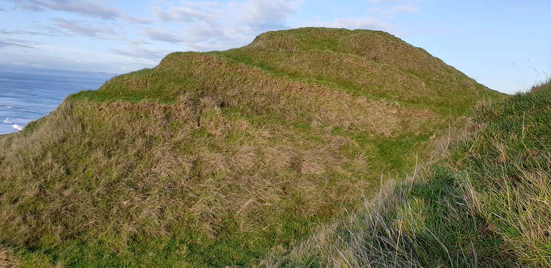
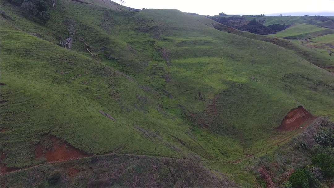
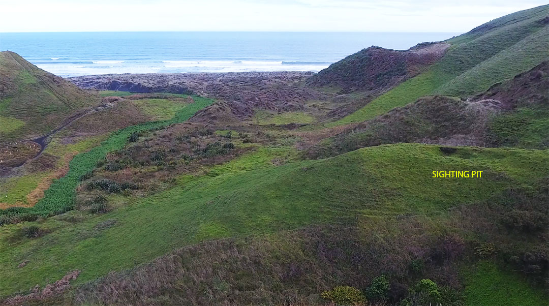
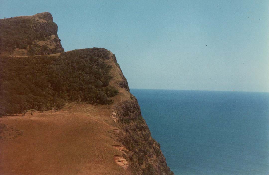
The impressive, purpose built mound, from the top of which one witnesses the winter solstice sunrise ascending into the sky from the highest point of Mount Karioi. This mound, complete with sighting pits in and around its summit, is situated only 1-mile further north up the coast from the Ruapuke stream set of dual mounds, terraces and sighting pits, once used for elevation calculations.
This author had a firm conviction that the ancient people of Ruapuke would have wanted to exploit the highest ridge of Mount Karioi as the outer marker for a winter solstice sunrise fix, so set about back-engineering where an observer would need to stand, near the sea coast, to witness the event. Some calculations in Red Shift astronomy program, Google Earth for elevations and distance readings, then trigonometry to establish the viewing position followed. Unsurprisingly, the observation position turned out to be a registered archaeological site, purpose-built by the ancient people for the solstice event.
In the above picture the sun has just risen on a slight diagonal angle towards the north, emerging from the highest point of the mountain, and its glaring light partially obscures the rise position. From the solar observatory mound, the ancient people could get a precise fix on the winter solstice day, and thereby keep their calendars 100% correct.
For a video of the 2020 winter solstice sunrise from Mount Karioi, see the following:
While our intrepid little group braved the mid-winter cold winds of the Ruapuke sea-cliffs, our New Zealand establishment archaeologists were tucked up in bed cosy and warm. Why should they venture out to explore when, according to what they've been indoctrinated to believe, no such thing as a solar observatory exists in New Zealand?
It must be terrible to be a hamstrung New Zealand archaeologist, not allowed to do actual "Archaeology".
Under present reporting conventions, they're permitted to forage around in middens, looking for a futile piece of obsidian or the like, but not much more than that. Any artefacts or structures they come across, these days, are not allowed to be more than 7 - 800 years old and to suggest otherwise would be heresy within their peer group, leading to career-suicide.
Essentially, these dumbed-down and compliant, social-engineers are a part of the ongoing problem and will never be a part of the solution in the foreseeable future, when it comes to laying out, before the eyes of the public, the true, unadulterated history of New Zealand.
Martin Doutré, 30th of June 2020.